
Agricultural land at auction, Arcidosso
Arcidosso- from € 6,264.00
- 25,830m²
Description
This description has been translated automatically by Google Translate and may not be accurate
Lot n.3
1/1 share of full ownership of land in the Municipality of Arcidosso (Gr).
Cadastral Data:
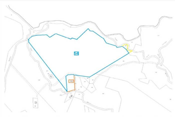
Municipality: A369 – ARCIDOSSO (GR) – LAND Cadastre – Sheet 49, Parcel 53, Subaltern -- – Nature T - LAND –– Consistency 10 are 93 cents quality VINEYARD
Municipality: A369 – ARCIDOSSO (GR) – LAND Cadastre – Sheet 49, Parcel 54, Subaltern -- – Nature T - LAND –– Consistency 45 ares 10 cents quality ARABLE LAND
Municipality: A369 – ARCIDOSSO (GR) – LAND Cadastre – Sheet 49, Parcel 64, Subaltern -- – Nature T - LAND –– Consistency 2 are 30 centimetres, quality COPPIX
Context:
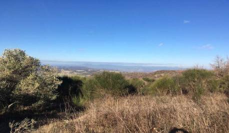
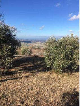
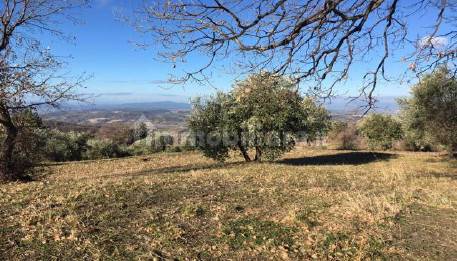
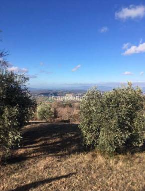
Arcidosso rises on the slopes of the western side of the mountain Amiata on the edge of the large woods that rise to the summit of the mountain.
The municipal territory appears to be characterized by very varied areas: ranging from the high part of the mountain (approximately 1600 metres) to the valleys which gradually descend towards the Maremma.
The territory is largely covered by beech and chestnut forests, the latter in particular have always played an important role in the country's economy and gastronomy.--18cbc95f81eecc7dc45cb1304c94f5f2!
1/1 share of full ownership of land in the Municipality of Arcidosso (Gr).
Cadastral Data:
Municipality: A369 – ARCIDOSSO (GR) – LAND Cadastre – Sheet 49, Parcel 53, Subaltern -- – Nature T - LAND –– Consistency 10 are 93 cents quality VINEYARD
Municipality: A369 – ARCIDOSSO (GR) – LAND Cadastre – Sheet 49, Parcel 54, Subaltern -- – Nature T - LAND –– Consistency 45 ares 10 cents quality ARABLE LAND
Municipality: A369 – ARCIDOSSO (GR) – LAND Cadastre – Sheet 49, Parcel 64, Subaltern -- – Nature T - LAND –– Consistency 2 are 30 centimetres, quality COPPIX
Context:
Arcidosso rises on the slopes of the western side of the mountain Amiata on the edge of the large woods that rise to the summit of the mountain.
The municipal territory appears to be characterized by very varied areas: ranging from the high part of the mountain (approximately 1600 metres) to the valleys which gradually descend towards the Maremma.
The territory is largely covered by beech and chestnut forests, the latter in particular have always played an important role in the country's economy and gastronomy.--18cbc95f81eecc7dc45cb1304c94f5f2!
Features
- Reference and listing Date
- 18-1038322-117327 - 02/10/2022
- contract
- Sale
- type
- Land - Agricultural land | Full ownership
- surface
- 25,830 m² - See detail
- floor
- Ground floor
- Cadastral data
- Layout 49 - Lot 53-54-64
- other features
- ArableVineyardCoppice wood
Energy efficiency
- energy certification
- Building not subject to energy certification requirements
Sales detail
- Sale type
- senza incanto
- sale date
- 05/09/2023, 12:00 AM
- condition
- Not open to participation
To participate
- minimum offer
- € 6,264.00
- Spend book debt
- No
- Undue contribution
- No
- sale location
- Piazza Fabbrini, 24 58100 Grosseto (GR) Italia
- submission deadline
- until 05/08/2023, 12:00 AM
Lot details
- Lot number
- 3
- number of properties
- 1
- category
- ALTRA CATEGORIA
Procedure data
- updated on
- 02/21/2023
- auction register
- Civil real estate applications
- procedure number
- 99/2017
- Procedure
- Esecuzione Immobiliare
- Court
- Grosseto
Floorplan
Additional options
Guber S.p.a.